A ship chart is a specialized navigation map designed to provide mariners with the information they need to plan and conduct safe journeys on the water. It can show coastlines, water depths, channels, hazards, navigational aids, ports, anchorages, and other important features that help vessels navigate from one location to another.
Often described as a mariner’s road map, a nautical chart provides a visual representation of the marine environment. It helps navigators understand their surroundings, determine a vessel’s position, identify potential hazards, and select appropriate routes.
Ship charts are used for many types of marine navigation, from coastal voyages and harbor approaches to longer offshore passages. Understanding the information presented on a chart is an important part of responsible voyage planning and navigation.
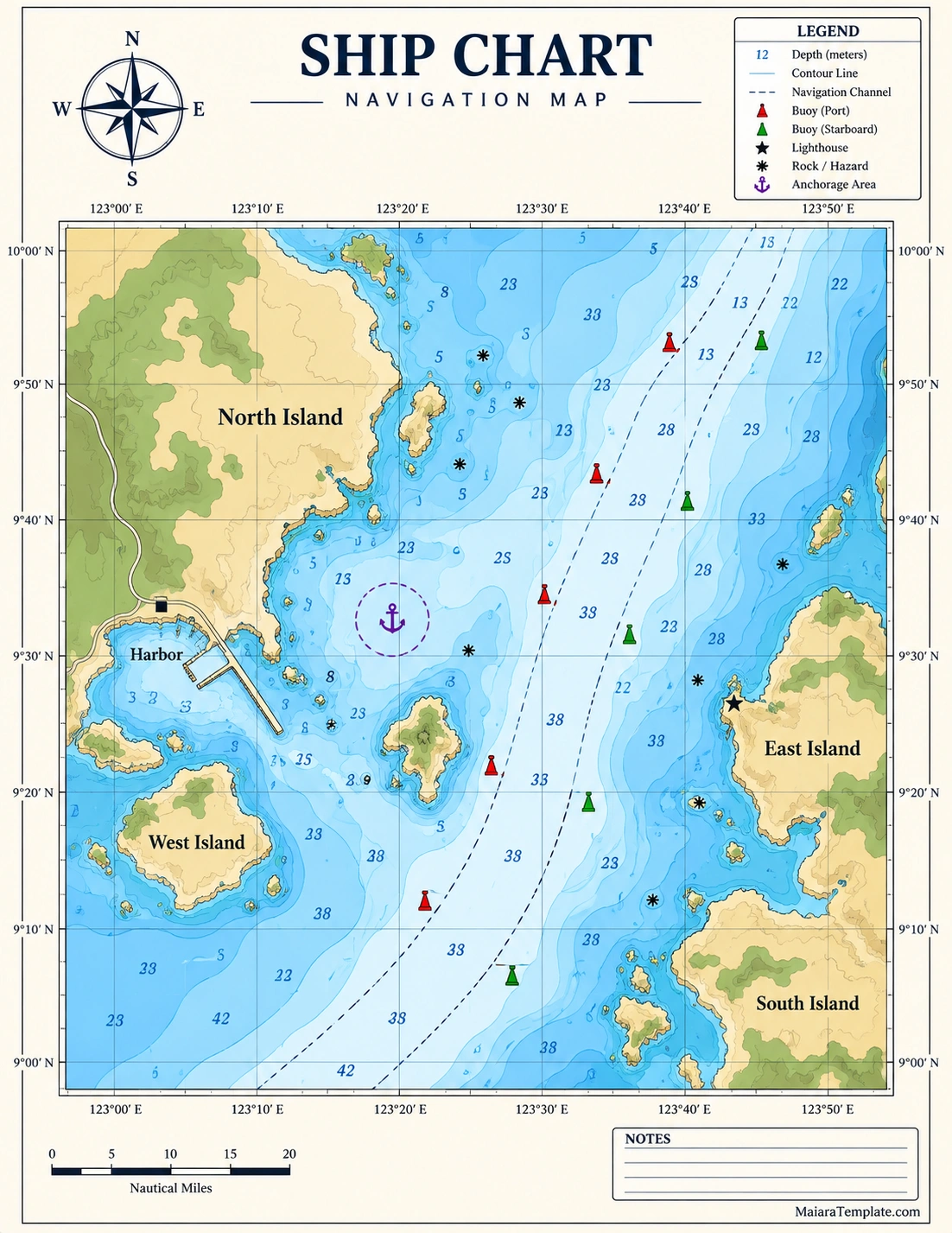
What Is a Ship Chart?
A ship chart is a detailed map of a marine area created to support navigation. It provides information that may not appear on an ordinary geographic map, including underwater depths, submerged hazards, navigation channels, buoys, lighthouses, anchorages, and other features important to vessels.
The term nautical chart is commonly used for these navigation maps. Depending on the context, people may also refer to them as marine charts, navigation charts, sailing charts, or sea charts.
The primary purpose is to help navigators understand the conditions around a vessel and make informed decisions about where and how to travel.
Why Are Ship Charts Important?
Marine environments can contain hazards that are difficult or impossible to see from the surface. A ship chart provides information that helps navigators identify these conditions before they become a problem.
Voyage Planning
Before departure, navigators can use charts to examine the intended route, identify important waypoints, evaluate hazards, and determine suitable approaches to ports or other destinations.
Position Fixing
Charts provide geographic references that can be used with navigation instruments and positioning systems to determine where a vessel is located.
Hazard Identification
Underwater rocks, shallow areas, wrecks, restricted zones, and other hazards may be represented using chart symbols and depth information.
Route Selection
A chart can help a navigator compare possible routes based on water depth, channels, coastal features, navigational aids, and other relevant conditions.
Harbor and Coastal Navigation
Detailed charts are particularly valuable near harbors and coastlines, where vessels may encounter narrow channels, shallow water, traffic routes, buoys, docks, and other navigational features.
What Information Does a Ship Chart Show?
A ship chart contains many layers of information. Learning what each element represents makes the chart much easier to interpret.
- Water depths: Depth soundings indicate the depth of the water at specific locations.
- Depth contours: Contour lines connect areas with similar depths and help show changes in underwater terrain.
- Coastlines: Shorelines identify the boundary between land and water.
- Navigation channels: Channels indicate routes intended or maintained for vessel navigation.
- Buoys: Buoys provide navigational guidance and can mark channels, hazards, or other locations.
- Lighthouses: Lighthouses and other fixed navigation aids help vessels identify positions and navigate safely.
- Wrecks and hazards: Chart symbols can identify submerged or partially submerged dangers.
- Anchorages: Designated or recommended anchoring areas may be shown on the chart.
- Ports and harbors: Important maritime facilities and harbor features can be represented in detail.
- Coordinates: Latitude and longitude provide geographic reference points for navigation.
- Scale: The chart scale indicates the relationship between chart distance and actual distance.
- Compass information: A compass rose or directional information helps navigators determine bearings.
Understanding Ship Chart Symbols
One of the most important skills in marine navigation is understanding chart symbols. Nautical charts use standardized symbols and abbreviations to communicate a large amount of information within a relatively small area.
Symbols may represent buoys, lights, rocks, wrecks, cables, pipelines, restricted areas, anchorages, channels, and other features. Depth numbers may also appear throughout the water area to indicate measured or charted depths.
The chart legend and applicable navigation references should always be consulted when interpreting unfamiliar symbols. A symbol should not be guessed based solely on its appearance.
How to Read a Ship Chart
Reading a nautical navigation chart becomes easier when you approach it systematically. Start with the chart information and scale before examining the planned route.
Check the Chart Scale
The scale tells you how much geographic area is represented. Large-scale charts generally provide more detail for a smaller geographic area, while small-scale charts cover larger areas with less detail.
Identify Latitude and Longitude
Latitude and longitude lines provide a geographic reference system. These coordinates can help navigators identify positions and compare locations along a planned route.
Examine Water Depths
Review the depth soundings and contours along the intended route. Water depth is particularly important because a vessel needs sufficient clearance beneath its hull.
Look for Hazards
Identify rocks, wrecks, shallow areas, restricted zones, and other potential hazards before selecting the final route.
Follow Navigational Aids
Buoys, lights, lighthouses, and other navigational aids can provide important guidance, especially when entering or leaving a harbor or following a marked channel.
Review the Legend and Notes
The chart legend explains symbols, abbreviations, colors, and other information used on the chart. Notes may also contain important information about the area represented.
Ship Chart vs. Ordinary Map
A standard geographic map and a ship chart both represent geographic locations, but they are designed for different purposes.
An ordinary map may emphasize roads, cities, terrain, political boundaries, and geographic landmarks. A nautical chart focuses on information that matters to vessels, including water depth, submerged hazards, channels, buoys, lights, anchorages, and marine boundaries.
This specialized information makes a ship chart much more useful for marine navigation than a general-purpose map.
Types of Ship Charts
Different types of charts can support different navigation needs. The appropriate chart depends on the vessel, route, geographic area, and stage of the voyage.
Coastal Charts
Coastal charts provide detailed information about areas close to shore. They are useful for vessels traveling along coastlines and approaching ports.
Harbor Charts
Harbor charts typically provide greater detail for ports, waterways, channels, docks, and other features in confined areas where precise navigation is important.
Approach Charts
Approach charts focus on routes leading toward harbors, ports, or other destinations. They can help navigators transition from open water into more confined waterways.
Electronic Nautical Charts
Electronic charts provide navigational information in a digital format and can be displayed through compatible electronic navigation systems. They can offer useful features such as zooming, route planning, and integration with positioning data.
Paper Nautical Charts
Paper charts remain useful as a physical reference and can provide a broad visual overview of an area. They also serve as an important backup resource when electronic equipment becomes unavailable.
How Ship Charts Help With Voyage Planning
Voyage planning involves much more than drawing a line between two points. Navigators need to consider the characteristics of the vessel, route conditions, hazards, weather, water depth, traffic, and other relevant factors.
A ship chart provides the geographic foundation for this planning process. By studying the chart before departure, navigators can identify potential problems and prepare an appropriate route.
Important planning considerations may include:
- Starting point and destination
- Available navigation channels
- Water depth and vessel draft
- Underwater hazards
- Harbor entrances and exits
- Safe anchorages
- Navigation aids
- Restricted or controlled areas
- Alternative routes
- Relevant chart notes and warnings
Tips for Using a Ship Chart Effectively
Good chart use requires careful attention to detail. A few habits can make navigation planning more organized and reliable.
- Use the correct chart: Select a chart that covers the intended navigation area and provides an appropriate level of detail.
- Check chart information: Review the chart title, scale, edition, dates, and other identifying information.
- Study the legend: Make sure unfamiliar symbols and abbreviations are understood before relying on them.
- Check depths carefully: Consider the vessel’s draft and the conditions that could affect available water depth.
- Identify hazards early: Review the entire planned route rather than focusing only on the destination.
- Mark important waypoints: Clearly identify significant points along the intended route.
- Keep information current: Navigation information can change, so use current and officially appropriate chart information for real-world navigation.
- Maintain a backup: Where appropriate, have a reliable alternative navigation method available.
Ship Chart Template for Planning and Education
A ship chart template can be useful for educational exercises, navigation concepts, classroom activities, presentations, or creating a visual planning worksheet. A template may include areas for coordinates, routes, depth information, notes, symbols, and other chart elements.
For professional marine navigation, however, a generic printable template should not be treated as a substitute for an official or otherwise authorized navigation chart. Real-world navigation requires current, accurate, and appropriate hydrographic information.
Common Mistakes When Reading a Ship Chart
Navigation charts contain a large amount of information, and misinterpreting even one element can lead to poor planning. Some common mistakes include:
- Ignoring the chart scale.
- Misreading depth information.
- Failing to check chart symbols and abbreviations.
- Overlooking hazards near an intended route.
- Assuming all charted information is current.
- Confusing geographic distance with navigational distance.
- Failing to consider the vessel’s draft and clearance requirements.
- Relying on a general map instead of an appropriate nautical chart.
- Using a generic chart template for actual navigation.
Frequently Asked Questions About Ship Charts
What is a ship chart used for?
A ship chart is used to support marine navigation by showing information such as water depths, coastlines, channels, hazards, buoys, lighthouses, anchorages, and geographic coordinates. It helps mariners plan routes and understand the waters through which they are traveling.
Is a ship chart the same as a nautical chart?
In general usage, yes. The term ship chart may be used informally to describe a nautical chart, which is a specialized map designed for marine navigation.
What are the most important features of a ship chart?
Important features include water depths, depth contours, coastlines, navigational aids, channels, hazards, coordinates, chart scale, symbols, and chart notes. The relative importance of each feature depends on the voyage and location.
What do depth numbers mean on a ship chart?
Depth numbers indicate charted water depths according to the reference system and units specified by the chart. Navigators should always check the chart’s notes and legend to understand the applicable datum and measurement units.
What is the difference between a paper and electronic ship chart?
A paper nautical chart is a physical printed navigation document, while an electronic chart is displayed digitally through a compatible navigation system. Both can provide marine navigation information, but their use depends on the vessel, equipment, regulations, and navigation procedures.
Can I use a printable ship chart template for navigation?
A printable template can be useful for learning, planning exercises, or presentations, but it should not automatically be used for real-world navigation. Actual marine navigation requires current and appropriate official or authorized chart information.
Why are ship charts important for safe navigation?
Ship charts provide information about the underwater and surface environment that helps navigators identify hazards, plan routes, determine positions, and navigate channels and coastal areas more safely.
Important Consideration for Real-World Navigation
A generic ship chart template is intended for educational, organizational, or illustrative purposes unless it is specifically produced and authorized for navigational use. Real-world navigation should rely on current, appropriate, and officially recognized nautical chart information and applicable navigation procedures.
Conclusion
A ship chart is an essential marine navigation resource that provides detailed information about waterways, depths, coastlines, hazards, channels, navigational aids, and other features important to safe voyage planning.
By learning how to interpret chart symbols, coordinates, depth information, scale, and navigational features, mariners can develop a clearer understanding of the waters around them. A well-organized chart can support route planning, position fixing, hazard identification, and coastal navigation.
Whether you are studying marine navigation, preparing an educational worksheet, or learning how nautical charts work, understanding the information contained in a ship chart is an important foundation for responsible navigation.
Download: Ship Chart Template

- Ship Chart Template - October 5, 2026
- Free Printable Table Tent Template - October 5, 2026
- Free Printable Supply List Template - October 5, 2026
